

Carbon Stock Assessment in Mangrove Plantation, Philippines
DeepForest Technologies Co., Ltd. conducted a survey on Banacon Island, Philippines, from April 2024 to June 2025, to assess carbon stock in mangrove plantation areas and evaluate the feasibility of carbon credit generation based on the survey outcomes.
■Drone and Ground-Based Approach for Mangrove Carbon Assessment
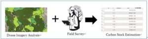
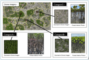
In this survey, high-resolution drone imagery was captured over the mangrove forest area, covering approximately 253 hectares in total. Based on vegetation density and other characteristics observed in the imagery, the plantation area was classified into multiple forest types. For each forest type, survey plots were established to collect essential field data—such as tree height, diameter at breast height (DBH), and tree count—required for estimating carbon stock.
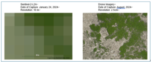
In mangrove forests, where tree density and height vary significantly and many stands consist of young trees, it is extremely difficult to accurately capture vegetation characteristics using standard satellite imagery with a spatial resolution of 10 meters (see Ref.1). In particular, trees planted within the last few years often cannot be visually distinguished from the surrounding environment, leading to frequent over- or underestimation of their area and spatial distribution.
 Ref.1:Satellite vs Drone Imagery in Mangrove Forest Monitoring
In contrast, the high-resolution drone imagery used in this survey successfully visualized forest boundaries and the spatial distribution of forest types with high clarity (see Ref. 2). As a result, we were able to accurately identify the actual area of reforested land—something that has been difficult to achieve using conventional methods. Furthermore, by integrating this imagery with ground-based survey data for each forest type, we achieved a more precise estimation of carbon stock.
 Ref.2:Mapping Mangrove Features with Drone and Ground-Based Imaging
■Achievements of This Survey
Through this survey, we demonstrated that combining wide-area, high-resolution drone imagery with detailed on-site plot surveys enables a scientifically robust and reliable assessment of carbon stock in mangrove forests. In addition, we facilitated the transfer of drone-based measurement techniques to local stakeholders, contributing to the development of a foundation for future long-term monitoring efforts.
We remain committed to supporting the creation of high-integrity carbon credits and providing technical solutions that contribute to environmental conservation and local community development.
We also actively seek collaboration with companies interested in forest resource analysis and carbon credit projects overseas.
If your organization is interested in partnering with us, please feel free to contact us.